I. Project Background
Landslides are characterized by high sliding velocities and long run-out distances. Frequently occurring in areas such as high, steep slopes, tunnel portals, and highway embankments, they not only cause direct economic losses but can also trigger secondary disasters, such as debris flows and traffic disruptions. To effectively mitigate landslide hazards, lattice anchoring systems are widely employed in slope stabilization projects due to their excellent support performance and adaptability.
However, the design of traditional lattice anchoring systems often relies on empirical formulas and finite element simulations, lacking a systematic understanding of actual deformation behavior. Therefore, conducting model tests—combined with advanced optical full-field measurement techniques to acquire deformation and strain field data—is of great significance for optimizing the design of these systems.
The XTOP3D XTDIC 3D full-field strain measurement system utilizes Digital Image Correlation (DIC) technology to monitor 3D full-field deformation in lattice anchoring models designed for landslide mitigation. Such simulation experiments facilitate a deeper understanding of landslide formation mechanisms, evolutionary processes, and failure modes. They reveal the mechanical responses and deformation patterns of geological bodies under various influencing factors, thereby enriching theories in fields such as geology and geomechanics and providing a scientific basis for design optimization.
 Technology to Deformation Monitoring of Lattice-Anchor Models for Landslide Control")
II. Occurrence and Consequences of Landslide Disasters
Prolonged, heavy rainfall can cause the water content of loess to exceed its shear strength, triggering transient sliding. Characterized by high sliding velocities and long travel distances, landslides often pose significant threats to infrastructure, resulting in damaged housing, disrupted roads, and the destruction of farmland.
Traditional mitigation methods suffer from issues such as reliance on empirical design, difficulties in controlling construction quality, and uncertain effectiveness; consequently, there is an urgent need to optimize stabilization measures through scientific testing.
III. Objectives of Landslide Model Tests
-
This experiment aims to simulate the process of a landslide disaster;
-
DIC optical measurement technology is used to evaluate the deformation response of lattice anchoring systems in landslide control;
-
DIC software is used to obtain the distributions of the slope surface displacement field and strain field;
-
DIC technology is used to analyze the stress distribution and deformation compatibility of the anchoring system;
-
DIC technology provides deformation data to support the optimization design of lattice anchoring systems.
IV. 3D Full-Field Strain Measurement Scheme Using DIC
Digital Image Correlation (DIC) is a non-contact, full-field deformation measurement method based on image matching, offering the following advantages:
High-resolution full-field monitoring: Enables the acquisition of displacement and strain data at any location;
Non-contact measurement: Eliminates human-induced disturbances;
Dynamic real-time capability: Suitable for monitoring the entire process of loading or landslides;
3D reconstruction capability: Allows for the generation of deformation and strain contour maps;
Rich data output: Capable of outputting displacement vectors, strain components, principal strains, etc.
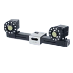
5. DIC measurement equipment selection
Industrial camera: 1200W pixels, 12mm lens;
Test format: 3.5*2.5 meters
Measurement principle:
By arranging random speckle patterns on the surface of the model, collecting images before and after deformation, and using the DIC algorithm to calculate the image matching displacement, the deformation field and strain field are obtained.
The model object is a landslide. Since the field of view is large and there are frames on both sides that will block the fill light, we use brush points to create speckles. The size and distribution density of the speckles are optimized. Several marking points are affixed to the concrete structure anchor in the middle to ensure that the texture features can be identified by the DIC measurement system.

VI. Testing Process
1. Model Preparation
Materials: Soil-sand mixture, experimental model surface representing geological layers;
Scale: 1:15;
Dimensions: Model size of 1.5 m × 4 m;
Observation Area: 1.5 m × 3 m.
 technology is used for deformation monitoring of lattice-anchor models in landslide prevention and control.")
2. Instrument Layout
-
Assembly, commissioning, and calibration of the XTDIC 3D full-field strain measurement system. Adjust the lens focal length to the midpoint between the front and rear positions, ensuring sufficient depth of field across the area of interest to capture clear images.
-
Loading process: A rear-mounted hydraulic device pushes the slope forward to simulate the forces acting on it during a disaster.
-
Adjust the frame rate of the DIC equipment and begin the experiment. (The image below shows the model after failure.)

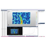
7. Test Results and Displacement/Strain Field Data
1. Displacement Field Contour Maps
Forward displacement map of the landslide face:
Slope crest area: Maximum displacement 344.419 mm
Slope toe area: Minimum displacement 143.101 mm
 technology.")
Heave displacement plot for the slope surface:
Slope crest area: Maximum heave displacement of 176.654 mm.
Slope toe area: Minimum displacement at the base of 2.231 mm.
 technology.")
Displacement curves (forward and upward) at key locations at the base and crest of the slope surface:
 technology.")
 technology.")
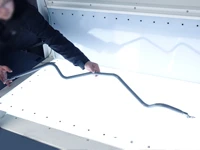
Displacement curves at key locations of the slope protection structure anchors:
 Technology")
Locations of slope cracks:
 technology.")
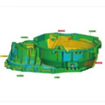
Final failure mode of the slope:
 technology.")
VIII. Value of the Model Test
This test utilized the XTOP3D XTDIC 3D full-field strain measurement system to achieve 3D full-field monitoring of slope deformation. Despite the significant depth of field between the foreground and background of the on-site model, the test yielded high-quality data. The DIC measurements allowed for clear observation of the entire slope failure process and the movement of anchors within the slope protection structure, providing effective and diverse data support for the experiment.
Strong scientific basis: Analyzes the load-bearing mechanism, failure modes, stress transfer patterns, reaction force modes, and cooperative working mechanisms of the lattice anchoring system;
Engineering practicality: Provides a reliable basis for optimizing the design of lattice anchoring systems;
Methodological innovation: Demonstrates the successful application of DIC technology in slope model testing, a method that can be extended to other fields of geotechnical engineering;
Decision support: Provides data to underpin the design and construction of landslide prevention and control projects.